Historical Background of Raymer/ New Raymer
Historical Background
Early History of the Region (1860s-1880s): Throughout the middle decades of the nineteenth century, nomadic Native American tribes traversed the landscape of present-day northeastern Colorado as they had for generations and the first waves of Euro-American explorers, fur trappers, frontiersmen and pioneers migrated up the South Platte River Valley and into the Colorado frontier. The site that would eventually be occupied by the town of Raymer (later known as New Raymer) sat vacant and unnoticed. Situated on the high semi-arid plains at an elevation of about 4,780’ above sea level and far from major watercourses and migrant trails, the land was occupied by an unbroken expanse of short-grass prairie that supported varieties of life adapted to that particular biome.
Suspended for previous millennia in an untrammeled state of nature, in the 1860s the area began to experience changes that would soon alter the course of its history and character. When the Colorado Territory was established in 1861, Weld County became one of its original administrative units. Originally occupying a vast swath of the territory’s northeast corner, the county was reduced in size over the following decades as it was subdivided into seven smaller counties. This placed the future Raymer townsite in the northeast corner of Weld County. Native peoples were accustomed to living off the land in this dry and seemingly barren environment. However, most Americans understood that the region was part of what had been declared the Great American Desert, a landscape unfit for agriculture and settlement. This was reinforced by the observations of pioneers and frontier travelers who passed through primarily during the summer months, when the treeless landscape above the South Platte River Valley turned dry and brown. (Alvin T. Steinel, History of Agriculture in Colorado, 1858-1926, pp. 245-254.)
Americans believed that traditional agriculture, in particular the raising of crops, could not thrive in much of northeastern Colorado due to the lack of adequate precipitation and the inability to bring irrigation to lands high above the South Platte River. However, as the Euro-Americans continued to migrate through this landscape in the 1860s and 1870s, they also noticed that the expanse of grass supported their livestock. Attitudes and practices evolved as they came to understand that the best uses of the shortgrass prairie would include stock raising and the planting of dryland crops.
Between 1868 and 1878, cattle king John W. Iliff established a massive ranching operation in northern Weld County that initially supplied beef to the crews building the Union Pacific railroad across western Nebraska and southern Wyoming. Iliff came to control extensive rangelands, in large part by having his ranch hands file homestead claims around water sources. These were fenced with barbed wire beginning in the mid-1870s and then integrated into the ranch as Iliff purchased the land from his employees. He imported cattle from southern Colorado, northern New Mexico and western Texas. Fattened on the rich prairie grass, the animals were shipped east to the Chicago slaughterhouses. Iliff’s ranch thrived for a decade until his death in 1878. (Alvin T. Steinel, History of Agriculture in Colorado, 1858-1926, p. 135 & 255-256; A History of the Pawnee National Grassland, Published by the Pawnee National Grassland, Arapaho and Roosevelt National Forest, No Date.)
During the summer of 1870, the federal government contracted with J. H. Martz to assemble and deploy a survey team to measure and map the township boundaries in northern Weld County. This launched the process that would eventually combine with federal homestead legislation to make the land available for legal settlement. No developed features were found in the future Raymer area by the surveying crew. Martz simply recorded measurements, prepared the map and field notes, and noted the region’s varieties of prairie grass. He also described the land as third-rate, by which he meant it would probably be good for little other than grazing. Throughout the 1870s, the area remained largely undeveloped and of little utility to the many pioneers who sought richer farmlands closer to water and developing towns. (Survey Plat and Field Notes, Townships 6-8 North and Ranges 57-64 West, Surveyor General’s Office, Denver, Colorado Territory, 15 August to 10 September 1870.)
In the fall of 1880, another survey team led by F. L. Biddlecom returned to the area to prepare more detailed measurements and mapping of the individual townships. Included in this survey was the acreage in Section 3 of Township 7 North, Range 58 West that would before long attract attention and develop into the town of Raymer. This time the surveyors came across an unnamed wagon road that extended on a diagonal through the northeast quadrant of the township. Aligned on a northwest-southeast axis, the road passed through the otherwise empty southwest quarter of Section 3 and may have connected the South Platte River road with Cheyenne. (Survey Plat, Township 7 North, Range 58 West, Surveyor General’s Office, Denver, Colorado, September to December 1880.)
As the years passed and many areas of Colorado experienced substantial growth and development, the land in the northeast quarter of Section 3 continued to sit vacant, a characteristic that would soon come to an end. During the 1880s, the rate of settlement on Colorado’s eastern plains increased. This was largely due to promotion by railroads, combined with the early work of agricultural scientists at the State Experiment Station in Cheyenne Wells. Investigations into dryland farming stressed the difficulties encountered in the semi-arid environment but encouraged settlers to stake their future on a region that was previously viewed as good for nothing but cattle grazing. What many of the pioneers experienced after a few years of planting crops and then watching them wilt without water under the searing sun was that farming proved exceedingly challenging. A good number either left the region defeated, shifted to stock raising, or went into other lines of work. (Steinel, History of Agriculture in Colorado, 1858-1926, p. 255; LeRoy R. Hafen, Colorado and its People, Volume I, 1948, pp. 433-434; Steven F. Mehls, The New Empire of the Rockies: A History of Northeast Colorado, p. 72-73.)
One prominent factor that initiated change in northeastern Colorado was the development by the Chicago Burlington & Quincy Railroad (CB&Q) of an east-west line from Holdrege, Nebraska (southwest of Kearney) to Cheyenne, Wyoming. With a route stretching across northeastern Colorado, the railroad’s managers planned to compete with the parallel Union Pacific line to the north for passenger and freight traffic. In June 1887, the CB&Q (operating as the Colorado & Wyoming) began laying track at the Colorado-Nebraska state line northeast of Holyoke and by September it had reached Sterling. From there, the line continued west across the prairie, passing the present-day location of New Raymer. The route then curved to the northwest to cross the Colorado-Wyoming state line, completing its 144-mile trek across northeastern Colorado. It then turned to the west and entered Cheyenne by the end of the year. (Robert Ormes, Tracking Ghost Railroads in Colorado, 1975, pp. 9 & 15; Tivis E. Wilkins, Colorado Railroads: Chronological Development, 1974, pp. 58 & 70; Franklin M. Jones, History of New Raymer, Colorado, 1943, p. 4; Carol Rein Shwayder, Weld County – Old and New, Volume I: Chronology of Weld County, Colorado, 1836-1983, p. A71 & A74; Shwayder, Weld County – Old and New, Volume XIII: Gazeteer [sic] of Railroads, p. 32.)
Although the CB&Q failed to draw substantial business from the Union Pacific, a number of freight and passenger trains traveled the route on a daily basis. With the railroad under construction, hundreds of homestead claims were filed and parcels of land purchased, and it was estimated that during the mid-1880s the population of northeastern Weld County grew by approximately 5,000 residents. While most settled in the countryside, others staked their claims in the small agricultural market towns that arose on the plains, many of them alongside the newly laid tracks of the CB&Q. As described by Colorado historian LeRoy Hafen in his 1948 work Colorado and its People, “The influx of homesteaders created a need for trade centers, as the new settlers were anxious for community life. Town site companies responded, platting towns at suitable intervals along the railroad lines. Water tank stations grew into villages; hopeful towns sprang from the prairie.” (Steinel, History of Agriculture in Colorado, 1858-1926, p. 254; LeRoy R. Hafen, Colorado and its People, Volume I, 1948, p. 434.)
The Rise and Fall of Raymer (1888-1908): The northeast quarter of Section 3 in Township 7 North, Range 58 West, was first owned by a young woman by the name of Emma Courtright. Born in Iowa around 1868, Emogene “Emma” Jane Courtright had moved west to Logan County by the late 1880s and was employed there as a dressmaker. Despite her youthful age and line of work, she actively acquired several parcels of land in northeastern Weld County between 1888 and 1891. Her brother Elroy was also in the area, working as an agent for the Crete Nurseries of Crete, Nebraska and promoting the sale of town properties and homesteads. (Elroy Courtright may have been selling trees to homesteaders so they could claim an additional 160-acres from the General Land Office under the Timber Culture Act. He may also have been associated with the Lincoln Land Company, which was beautifying barren townsites with greenery to make them attractive to potential buyers. This likely placed him in the position of knowing where new towns would be established. Because of his work, it is possible that Elroy pointed Emma to the future Raymer townsite and assisted her with acquisition of the land.) Rather than file a homestead claim with the General Land Office, in February 1888 Emma purchased the 157.67 acres that made up the entire northeast quarter of Section 3 for a fee of $187.09. (Jones, History of New Raymer, Colorado, p. 6; US Federal Census Records, Emma J. Courtright, 1870 (Oxford Mills, IA) and 1900 (Elk River, Routt County, CO); Land Patent Issued to Emma J. Courtright, NE¼ of Township 7 North, Range 58 West, General Land Office, 6 June 1889 (Note: Emma purchased the property in February 1888 and sold it later that year, prior to receiving the patent).)
The land was situated along the newly-built CB&Q railroad, at a point on the map where it planned to build a depot and encourage the development of a new town. In March 1888, the railroad assigned workers to dig a well that would supply water for its engines. Reaching a depth of 65’ by mid-month, the men had still not struck water although they were pulling up ancient animal bones, samples of petrified wood, and an abundance of mica. Over the following decades, the lack of a reliable public water source proved to be a persistent problem for the town. Despite this seemingly temporary obstacle, several business owners expressed interest in establishing themselves in the new town and during the summer of 1888 a number of commercial buildings emerged. (Bud Wells, Homesteading the Dryland: A History of Northeast Weld County, Colorado, pp. 292-293.)
On 6 October 1888, Emma Courtright made a sizable profit when she sold the property for $1,000 to the Lincoln Land Company. Founded in 1880 and based in Lincoln, Nebraska, the firm was a subsidiary of the CB&Q. As it had already done across Nebraska over the previous years, the railroad sought to locate stations and towns at ten-mile intervals along its route through northeastern Colorado. The railroad’s managers knew that this distance was within one day of travel for area farmers to reach the nearest depot and market town. (Present-day maps of northeastern Colorado still show the regular spacing of towns at ten mile intervals along the rail route that resulted from the CB&Q’s development through the area in 1887.) The mission of the Lincoln Land Company was to establish towns, have them platted, and arrange for the installation of necessities such as streets and water wells. The company then promoted settlement and the sale of lots, ensuring that the population along the route would increase and provide business to the railroad. (Jim McKee, “The Lincoln Land Co. Developed Much of Nebraska and Created Many of its Towns,” Journal Star, 23 December 2012; Warranty Deed, NE¼ of Sec. 3, T7N-R58W, Emma J. Courtright to the Lincoln Land Company, 6 October 1888; Kenneth Jessen, Ghost Towns, Eastern Colorado, 2009, p. 216.)
During the late 1880s and early 1890s, the Lincoln Land Company was busy establishing a series of towns, whistlestops and sidings along the rail route. From the Nebraska state line to the Wyoming state line these included Amherst, Holyoke, Paoli, Haxtun, Dailey, Fleming, Galien, Logan, Willard, Stoneham, Raymer, Buckingham, Keota, Sligo, Grover and Hereford. Many were named by the company to honor its executives and managers. While a few of these locales thrived and grew into towns, others never took hold or simply died off over the following years due to a combination of environmental and market factors that made their chance of survival tenuous from the beginning. (Jessen, Ghost Towns, Eastern Colorado, numerous pages; William Bright, Colorado Place Names, numerous pages; LeRoy R. Hafen, Colorado and its People, Volume I, 1948, pp. 434-437.)
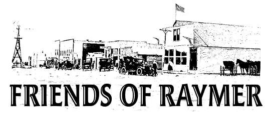
With the Lincoln Land Company as its new owner, the acreage in the northeast quarter of Section 3 was platted with a townsite named for George Andrew Raymer (1857-1907), assistant chief engineer of the CB&Q railroad. The firm surveyed and laid out a small area of blocks centered on Shirley Avenue, one block east of present-day Centre Avenue. Shirley Avenue was named for Samuel J. Shirley, local real estate agent, insurance agent and editor of the Raymer Herald. He used his newspaper to promote Raymer as an ideal opportunity for farmers in the heart of northeastern Colorado’s “rain belt.” Despite efforts to attract large numbers of settlers, the Town of Raymer experienced a limited boom as properties were sold and a bank, post office and newspaper emerged in 1888 and 1889. Other pioneer enterprises established during the late 1880s included a livery stable, grocery store, hardware store and saloon. (Jones, History of New Raymer, Colorado, pp. 6-7; Shwayder, Weld County – Old and New, Volume I: Chronology of Weld County, Colorado, 1836-1983, p. A75 & A78; Wells, Homesteading the Dryland: A History of Northeast Weld County, Colorado, pp. 292-294; Steffen, Vangraefschepe & Wells, A History of New Raymer, Colorado on its Centennial, 1888-1988, p. 8.)
The winter of 1886-1887 brought bitter temperatures that killed thousands of cattle in northeastern Colorado. Despite this loss, beef prices dropped in the Chicago market. In 1889-1890, drought settled upon the region. The Panic of 1893 caused further damage when it thrust the nation into an economic depression and damaged commodity prices. Conditions proved so difficult that many of the pioneers who sought to establish themselves along the CB&Q route gave up and moved away. The same proved true for those who settled in and around Raymer. Businesses closed, the Raymer Herald folded, and by 1894 the town had died off. Every one of the settlers moved on in search of greener pastures. Rather than standing as a ghost town, the buildings were either moved or dismantled by area ranchers the following year and the townsite was almost completely emptied. Despite the belief that “rain would follow the plow” and success was bound to come to those who worked hard and persevered, the hopeful pioneer town of Raymer had lasted a mere six years and simply disappeared. (A History of the Pawnee National Grassland, Brochure Published by the Pawnee National Grassland, Arapaho and Roosevelt National Forest, Greeley, Colorado, c1986; Jones, History of New Raymer, Colorado, pp. 6-7; Jessen, Ghost Towns, Eastern Colorado, 2009, pp. 216-217; Shwayder, Weld County – Old and New, Volume I: Chronology of Weld County, Colorado, 1836-1983, p. A80; Wells, Homesteading the Dryland: A History of Northeast Weld County, Colorado, pp. 294; Mehls, The New Empire of the Rockies: A History of Northeast Colorado, p. 74.)
In the early fall of 1902, the Greeley Tribune sent a reporter into the countryside to inspect the region’s school districts. The resulting article described the abandoned townsite in the following terms: “Raymer is another monument to rain-belt disappointments. Once eighty children of school age dwelt in the district. Stone houses and stores, prosperous livery stables and hotels and all the improvements of a prairie village, including a fine two story school house were there, and every quarter section was taken up. Only the school house and barren siding on a one horse-railroad remain. The nearest post office is thirty miles away.” Raymer had entered the new century almost completely vacant, awaiting its next phase of development. (“Visiting Some Schools,” Greeley Tribune, 16 October 1902, p. 5.)
New Raymer Emerges (1909-1929): The Lincoln Land Company held onto the vacant townsite into the early twentieth century. In July 1909, the firm sold the property along with several adjacent parcels to W. W. Baldwin and W. E. Whittier for $3,375. This transfer marked the beginning of Raymer’s revitalization, primarily by a second wave of pioneers from Nebraska who had learned how to farm and ranch on the semi-arid plains. Above-average rainfall and rising grain prices combined with the 1909 passage of the Enlarged Homestead Act, which allowed for 320-acre claims, to encourage renewed settlement of the area. Around 1900, William Baldwin was a Logan County sheep rancher and his junior partner, William Whittier, was living on his family’s farm in Smith County, Kansas. The real estate firm of Baldwin & Whittier was established in 1907 in Sterling and the partners maintained a branch office in New Raymer from 1909 to 1912. (Hafen, Colorado and its People, Volume I, 1948, pp. 434-437; Warranty Deed, Lincoln Land Company to W. W. Baldwin and W. E. Whittier, 12 July 1909; US Federal Census Records for William W. Baldwin, 1900 (Leroy, Logan County, CO) and 1910-1920 (Sterling, CO); US Federal Census Records for William E. Whittier, 1900 (Smith County, KS) and 1910-1940 (Sterling, CO); Jones, History of New Raymer, Colorado, p. 40.)
In the Raymer Enterprise, Baldwin & Whittier advertised its sale of irrigated and “upland” (non-irrigated) farms, along with ranches and town properties. Lands available in the countryside included both deeded acreage and homestead relinquishments. The firm also promoted the New Raymer townsite and in December 1910 offered any doctor or the owners of any butcher shop, drug store or bank willing to erect a two-story brick or cement block building a free lot to build upon. By the end of 1912, Baldwin and Whittier parted ways to operate separate Sterling-based real estate companies. Much of their early success was tied to the rebirth of New Raymer as an active market town for the reemerging farming and ranching district. (“Baldwin & Whittier,” Raymer Enterprise, 1 September 1910, p. 4; “Baldwin & Whittier,” Raymer Enterprise, 22 December 1910, p. 10; State Business Directory, New Raymer Listings, 1911.)
On 23 July 1910, the plat of the Baldwin & Whittier Addition to the town of Raymer was filed with the Weld County clerk and recorder. However, the site had been surveyed a year earlier when the men acquired the land. Situated north of the CB&Q line, the expanded townsite was laid out to encompass and enlarge the earlier town of Raymer. In its entirety, the new townsite measured just three blocks in any direction and much of that was formed by the Baldwin & Whittier Addition. The main commercial thoroughfare, designated Centre Avenue, was aligned to run on a north-south axis through the middle of the town. East and west of the planned commercial street were numerous residential properties that faced onto Shirley Avenue and Bronson Avenue. (Plat of Baldwin & Whittier Addition to the Town of Raymer, Recorded 23 July 1910.)
Development began in 1909, months before the plat was filed. The town received a post office that year, and to distinguish the new community from the old (and reportedly to distinguish it from the town of Ramah in El Paso County, which apparently had a similar pronunciation) the US Postal Service insisted that it be known as New Raymer. This moniker led to confusion about the town’s true name that persists through the present day. The following year saw the founding of the Raymer Enterprise newspaper. By the time the plat for the Baldwin & Whittier Addition was filed in mid-1910, Centre Avenue was already occupied by several commercial buildings. Among the early businesses established there were a blacksmith shop, restaurant, grocery, hotel, livery stable, general store, lumberyard, and hardware store. (Jones, History of New Raymer, Colorado, pp. 6-7; State Business Directories, New Raymer Listings, 1911; Shwayder, Weld County – Old and New, Volume I: Chronology of Weld County, Colorado, 1836-1983, p. A101-103.)
In July 1912, all of the unsold lots in the townsite were acquired from Baldwin & Whittier by C. F. Peckham of Gothenburg, Nebraska, in a trade that involved a threshing machine and $8,100 in cash. Eager to sell properties, Peckham advertised that “This town is in the heart of a fast developing farming country, showing splendid crops. Land is cheap and settlers are coming. It is absolutely the best undeveloped field that we know of and offers a splendid opening for a Bank, Doctor, Drug Store, and other enterprises.”
Claiming that profits could be made simply by hiring out the work of farming, Peckham neglected to mention the area’s semi-arid climate and lack of irrigation that in reality made agriculture a difficult and risky business. (Jones, History of New Raymer, Colorado, p. 40; “Business Opportunities in Raymer…,” Raymer Enterprise, 22 January 1914, p. 4.)
During the 1910s, Center Avenue filled with commercial enterprises and additional houses were constructed on the nearby residential lots. Two small banks were established, the Raymer State Bank (1915) and Farmers & Merchants State Bank (1918). In 1921, they merged as the Raymer State Bank and survived for another five years before its doors were closed and assets liquidated. World War I increased demand for farm products, including meat and dryland drops such as wheat and corn. The 1916 Stock Raising Homestead Act allowed for claims of up to 640 acres in arid locales, making ranching more viable. These developments spurred renewed settlement on the plains of northeastern Colorado, boosting economic development and the population of the region’s small towns. (Jones, History of New Raymer, Colorado, pp. 6-7; State Business Directories, New Raymer Listings, 1911-1920; Mehls, The New Empire of the Rockies: A History of Northeast Colorado, p. 144.)
New Raymer was incorporated in 1919 and the following year the federal census recorded 267 persons living there with another 574 in the surrounding countryside. These numbers remained steady through the 1920s. A small number of businesses and homes installed individual electric lighting systems in 1916 and in 1921 the town purchased a generator that powered several street lights. Around 1930, full-time electric service was secured for the community. It would be many years before a municipal water system was installed. Despite its small size and the lack of some modern conveniences, New Raymer appeared to have a bright future. (Fourteenth Census of the United States Taken in the Year 1920, Volume I: Population, 1921; Shwayder, Weld County – Old and New, Volume I: Chronology of Weld County, Colorado, 1836-1983, p. A115 & A137; Steffen, Vangraefschepe & Wells, A History of New Raymer, Colorado on its Centennial, 1888-1988, p. 17 & 23.)


Want to help? Have additional information?
We NEED You!
We will need lots of volunteers to help with various things from fundraising to actually helping with the building restoration. We are also always looking for more information and photos about this building and the others in historic Raymer, CO.